LOOKBACK: Baird Island name for little spot on Austin Mill Pond
Naming honors Austinite who ignited area’s transformation from swamp to park in early 1900s
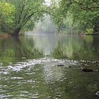
In July 1914, Austinites were looking over a nationally known designer’s plans for creating a state park along the Cedar River just north of downtown.
“The plans have been viewed by half a hundred people and all are of one opinion: that the plans showing the most water is the one to adopt,” the Austin Daily Herald wrote at the time.
One option for the future Horace Austin State Park had called for creating more islands on the Cedar River, which already boasted a handful of mostly wooded islands across mostly swampland upstream from the downtown dam. While that plan looked good, most thought it would create too much land than water and cost more money.
In the end — after dredging and filling took more money and time than expected — Austin chose to connect islands to the mainland and remove others through dredging to create a lake-like stretch of the Cedar River for its new park.

After dredging ended in summer 1922 — and much material had been dumped in Austin Mill Pond’s southwest corner for a swimming beach — one island remained. Yet, that island actually was not an original; it was created from dredged material
Now, after nearly a century without an official name, Austin Mill Pond’s small island now bears the name of Baird Island in honor of Lyman D. Baird, one of Austin’s “Pillars of the City” who spearheaded the effort starting in 1905 to turn the swampland backwaters of the Austin Mill Pond area into a large park.

Baird’s plaque — added two years ago by the city — is on Austin’s flood wall just west of the island with other “Pillars of the City,” including George A. Hormel and Jay C. Hormel.
Honoring Baird
Long considered one of Austin’s most-helpful citizens, Baird served as Austin’s mayor and city attorney and in leadership roles at the county and state levels. He advocated for improving Austin in many ways through making financial gifts and providing other support.
In 2019, Cedar River Watershed District outreach coordinator Tim Ruzek proposed the name Baird Island to the Austin Park & Recreation Board, which owns the island, and the board approved it. The naming also got previous approval from CRWD’s Citizens Advisory Committee and the local planning committee for Austin’s hosting of the We Are Water MN statewide traveling exhibit in 2019.
“Several other citizens, including George A. Hormel, played big roles in making Horace Austin State Park a reality but Lyman Baird ignited the whole effort to transform the swampland for the better,” Ruzek said. “Aside from his donation of money and land, he had the first park designs created for this area.”

Ruzek planned to organize a 2020 event with free canoe and kayak rentals to celebrate the naming of Baird Island but that was canceled due to the Covid-19 pandemic. He now plans to do a couple of virtual events on the water near the island in the coming weeks with the Austin Area Chamber of Commerce and Hormel Historic Home.

Historical and news records do not indicate any official name given to the island except briefly in the 1970s when a few articles referred to it as Cedar Island. That was part of a city beautification project at Austin Mill Pond and the name apparently did not catch on.
Baird’s ‘magnificent offer’
By his late 40s, Baird had achieved enough success and wealth to offer what the newspapers in 1905 called a “magnificent offer” from him and his wife, Lila, to turn the Cedar River backwaters into a park. This area was known as a swamp and dumping grounds for citizens with a reputation for mosquitoes and bad odors.
In October 1905, the Bairds made the offer to the City of Austin after Lyman had thought about such a gift and park plan for years. He wanted to create a park road from above the downtown dam all the way to Oakwood Cemetery (which never happened to that extent). He also wanted to dredge the river and beautify its various islands.
With the Baird donation of money and land — along with others deeding their land — the city agreed to match the financial contribution and work to transform nearly 50 acres of water, shoreline and wooded islands.

Eventually, this effort took off in 1913 when the state Legislature agreed to give Austin a state park named in honor of former Minnesota governor Horace Austin. It still would take the next decade until the park was completed due to the extent of work and money needed to transform the area.
Baird never got to see the completion of Horace Austin State Park as he died in 1921 at age 63. Dredging of the Cedar River for the state park ended in 1922.

Island nearly lost due to 1960s dredging
Horace Austin State Park started fading in the 1930s when the state changed it from a state park to a wayside area. By the late 1950s, its nearly 50 acres of land and adjacent low-lying property was starting to be opened for commercial and residential development.

Out of this movement came a major plan to dredge the Cedar River at Austin Mill Pond for a variety of reasons but mainly to use dredged material to build on for Austin’s first indoor mall (the former Austin Packaging and Bellisio’s building on North Main Street).
A Herald editorial on Jan. 30, 1963, wrote that the Cedar River long had been in need of dredging and that an opportunity had arisen with no cost to the city with the Western Land Corp.’s plan for building the mall.
Western Land proposed dredging the river from above the downtown dam and upstream through Austin Mill Pond and a little way more. Dredged material would be used as fill for the new shopping center, and the river would be dredged to an average depth of 9 feet. At the time, Austin Mill Pond had spots there were 1 foot deep or less.
With this plan came the risk that dredging could cause the loss of the island.
“Objections have been expressed to the proposal to remove the small island in the river,” the Herald wrote. “We understand there is reason to believe that the dredging of that area of the river will likely cause the island to disappear, and its removal is thus unavoidable.”
The editorial noted that the island was not a natural feature — created in the 1920s dredging.
“When the river was dredged many years ago to fill the slough area, which then existed at what is now the north end of Main Street, some of the dredged material that was not needed was dumped back into the river to form the island,” the Herald wrote.

Some argued that the island was useful for ducks, the Herald wrote, but the newspaper proposed the city instead make some of its extensive shoreline property in the area to create privacy spots for waterfowl nesting.
The Herald emphasized it hoped nothing would “stand in the way to block the dredging project” as the editorial staff believed the work would be highly beneficial to the river and the community.
Just a few days later, the Herald ran the headline: “Cedar River Island Safe, Nelson Tells City Council.” It was a Feb. 2, 1963, article about Austin’s city engineer Roger Nelson easing concerns about the island.
“Austin people concerned about the possible loss of the little island at the north end of Main Street may now stop worrying,” the Herald wrote.
Nelson told the city council at a Friday night meeting that he was “quite certain now” that Western Land would avoid taking the island when it embarked on dredging.
“The engineers have gone over the soundings taken in the river,” the article stated. “The water is quite deep near the island — 10 to 11 feet on its south side, 8 to 10 on the west and 4 to 5 on the north. It is east of the island where the river starts getting shallow.”
Western Land would start dredging east of the island and let the island remain. At the time, the island still was property of the State of Minnesota, which approved the dredging plans. Today, the island is owned by the city.
“The city council went on record asking Nelson to do all in his power to retain the island,” the Herald wrote. “Nelson appeared convinced the island would remain.”
Austin’s mayor in 1963 — Roger Svejkovsky — was happy about the outcome as he had received many letters about the island.
Members of the Austin Izaak Walton League club also voiced pleasure that the island would be spared, emphasizing its value as a wildlife shelter, particularly for ducks and geese.
Even after all that drama, just six years later the Herald ran a photo of the island cleaned up with the caption: Can anybody think of a worthwhile use for an island?”
This photo on Sept. 6, 1969, related to the Austin Parks & Recreation Department seeking suggestions for using the island after “vastly improving its appearance.” Citizens with ideas were encouraged to contact city staff.

In April 1970, a Herald columnist suggested making a “nice park out of the island in the widening of the Cedar River on North Main, with a walking bridge from the shore to the island like Albert Lea has in Fountain Lake.” He suggested putting a few benches on the island and building a rock wall around it for a better look.
By July 1977, however, the island was grouped into the rest of the Austin Mill Pond area’s description as an “eyesore.” At the time, the city planned to transform the area, including what they called “Cedar Island,” and the nearby shoreline of Austin Mill Pond.
“Long an eyesore in downtown Austin’s landscape, the Cedar River on N. Main St. is undergoing alterations destined to make it an appealing part of the city’s core,” the Herald wrote on July 8, 1977.

Austin’s North Main Beautification Committee finalized plans for plantings and landscaping of the island and former Horace Austin State Park property that was not developed. This included placing a fountain in the river near the island.

‘Ghost Islands’ of Austin Mill Pond
After completion, Horace Austin State Park still was described in a 1922 book on Minnesota’s state parks as having “ a number of deeply wooded islands,” a description used since the mid-1910s. That might have been the original plan but dredging for the park had removed islands or connected them to the mainland.
In August 1915, plans were in place to contract for dredging the park that year before winter set in using one hydraulic dredger and a bucket dredge.
On Sept. 22, 1915, the Herald reported that dredging had begun on the park.
“Work will be pushed day and night until it freezes up,” the newspaper wrote.
Major removal of the islands began after the state Legislature in 1919 approved $15,000 for dredging and other work at Horace Austin State Park.
In May 1920, an Albert Lea newspaper reported the dredger was being moved from its winter storage at the Hormel plant to the state park to resume dredging. That year, plans called for removing 40,000 yards of sediment from the main channel.
During dredging, crowds lined the riverbank to watch the big dredger. Work involved filling small channels of the river to connect islands to the mainland.
“This will give room for a fine line of trees and for drives and walks from Main Street,” a news article stated.
In November 1921, the Mower County News ran the headline: “Island in Cedar River is Rapidly Disappearing.” In this case, it was a good thing.
“Horace Austin State Park is beginning to take form,” the article stated Nov. 7, 1921. “One of the islands in the middle of the river is rapidly being pumped onto the beach.”

A contract called for 50,000 square yards — nearly eight football fields — of material to be pumped from the river. Work was expected to wrap up in summer 1922.
About 2 feet of sand was deposited on the beach, “and it is planned to remove all islands east of Evans Bluff.” When completed, the park “will present a fine appearance and be a mecca for the children.”
How the community got to the mostly island-free park plan started back in summer 1914.
Fred Nusshummer, a nationally known landscape artist who was St. Paul’s parks superintendent, was hired to design Horace Austin State Park. Nusshummer gave plans for an Austin committee and others to consider along with a report from the state’s drainage engineer.
One plan called for a walk along the river throughout the park and path from Main Street out onto what was called Padden’s Peninsula. A footbridge would connect the mainland with a small island and another footbridge from the island to a bigger island.
“The plan will make a fine lake with a large channel for the river, which will give our people plenty of boating and bathing,” the Herald wrote.
While the plan for more water than land won out in the end, it wasn’t without some effort to appreciate the area’s original islands.
In August 1915, the Mower County Transcript ran an account of the various islands.
“Imagine this 50 acres of swamp transformed into the Eden of Austin,” the article stated on Aug. 25, 1915.
The newspaper mentioned how this stretch of the Cedar River had been known at times as Lake Lincoln, Coon Lake, Mud Lake and Stump Lake. Its islands carried the names of Cattail Island, Isle of Cutting Grass, Nut Grove, Willow Bank and Plum Grove.

Isle of Cutting Grass was north of a landing off North Main Street and “had a great deal of sharp-edged grass as well as black currants, black haws and grapes.”
Cattail Island was northwest of the landing and noted for cattails along with grapes, black haws, clack currents, ferns and grass.
Nut Grove Island was north of the Isle of Cutting Grass, with a lake called Mud Lake and Lilly Bay, which was covered with lilies when they were in season. Considered a good picnic place, it also hosted grapes, pignuts, butternuts, cattails, thorn apples, black haws and pond lilies.
Willow Bank was northwest of Cattail Island and, of course, had many willows.
Plum Grove was west of Nut Grove and derived its name from the great quantity of plums on the island. Dogwood covered some of the island that also had Inland Pond and a swimming hole called Second Sand Pit. The island also was a great picnic area.